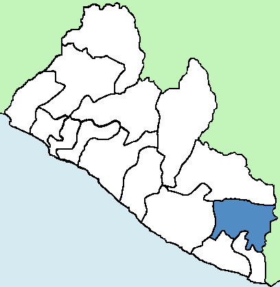
River Gee
Pronunciation: river gee
|
|||
| Established | -Hinterland -Eastern Province 1964: Grand Gedeh County June 2000: River Gee County (split from Grand Gedeh County) |
Capital | Fish Town |
| Location | North East | Area | 5,113 sq km; 1,974 sq mi; 5.3% |
| Population | 124,653 (2.4%) | Population Density | 63.1 |
| Tribes | Grebo 92%, Krahn 6%, Other 2% | Religion | Predominantly Christian with small number of Muslims & Traditionalists |
| Administrative Districts |
|
Electoral Districts | 3 |
River Gee is Liberia’s fourteenth county, established in 2000 after being separated from Grand Gedeh County. It is named after the Gee River which flows through its territory and had Fish Town as its capital. River Gee covers over 5% of Liberia’s land area and holds 2.4% of the nation’s population, resulting in a population density of around 63 people per square kilometer.
The split from Grand Gedeh was primarily due tensions between the Grebo tribe in southern Grande Gedeh and Krahn tribe in the northern part of the county. The Grebo wanted a separate political entity as they felt underrepresented and neglected by the leadership in Grand Gedeh, which was dominated by the Krahn tribe. The creation of River Gee as a separate county aimed to provide better governance, representation, and local administration for the Grebo population.
River Gee people are indigenous and often referred to as interior or inland Grebo. They are from the Kwa linguistic group to which Kru, Krahn, Sapoe and Bassa belong.
The majority of the people of River Gee County are subsistence farmers. Until the advent of corporate investments, they engaged in production of rice, cassava, potatoes, eddoes, beans, okra, eggplants, bitter-balls, pepper and other food crops.
The enthusiasm of the people of River Gee over their county status is overwhelming. However, it is not lost on them that the county lags behind others in terms of infrastructure and socio-economic development.
-River Gee in the Transformation Agenda, 2013
The county features hilly terrain with significant rivers including the Cavalla, Dugbe, Gee, Gbeh and Nun. It also retains lush vegetation and is home to the Grebo National Forest in the Gloarro belt. The major highlands are the Tienpo Mountain and the Killepo Range. Although it has lost some of its forest to farming, it still has the abundant vegetation that is common in most rural Liberian counties.
Credit: Wikipedia
Credit: Wikipedia
Outlook on development in River Gee follows the rest of the country with poor infrastructure, insufficient health care facilities and a general lack of social amenities.
Over-concentration of facilities and services in Monrovia has led to the lopsided development of the country, where rural areas have been left behind. River Gee is no exception. Stark disparities in living standards continue to plague the County. Inadequate or non-existent basic infrastructure continues to threaten the quality of life.
River Gee CDA, 2008
Sources
2022 Liberia Population and Housing Census. Liberia Institute of Statistics and Geo-Information Services (LISGIS). June 2023.
53rd Legislature Republic of Liberia. Know Your Senators. National Democratic Institute. Jul. 2012. Web.
Cahoon, Ben. Counties of Liberia. World Statesmen. Web.
Davies, Jarp. Approximately Forty Schools Closed in River Gee County Due to Lack of Teachers. 6 Apr. 2021. Web.
House of Representatives. Legislature of Liberia. Web.
Law, Gwillim. Counties of Liberia. Statoids. 2013. Web.
Liberia River Basins 2016. Drainage Divisions and River Basin Boundaries. Liberian Hydrological Service & Norwegian Water Resources and Energy Directorate. May 2016. Web.
River Gee Brief History. Lift Liberia. Republic of Liberia. 2009. Web.
River Gee County Development Agenda. Republic of Liberia. 2008. Web.
River Gee County Development Agenda. Republic of Liberia. 2025. Web.
River Gee in the Transformation Agenda. New Liberia Newspaper. 23 May 2013. Web.